“冰路卫星”全称“京师一号”,是我国“三极遥感星座观测系统”首颗试验卫星,2019年9月12日于太原卫星发射中心搭载长征四号乙运载火箭成功发射,主要用于极地气候与环境监测。对于促进我国极地与全球变化研究具有重要意义。该卫星搭载超宽幅中分辨率相机(分辨率80米、幅宽800公里)、高分辨率相机及船舶AIS接收机,单星可实现5天内对南北极区域全覆盖观测,填补国际250米低分辨率与30米高分辨率数据间的空白。\n
BNU-1数据为经过几何校正和辐射校正的Level 1产品,数据集共包含覆盖南北极的影像2499景。数据采用逐景存储方式,UTC时间制,数据格式为*.tif,命名方式:BNU1 PMSk yyyymmddhhmmss.yyyymmddhhmmss. 10k.000k.00k Bk”是固定格式,yyyymmddhhmmss表示影像获取时间,其中 yyyy是年份,mm是月份,dd表示日,如“01”代表每个月从01号开始,hhmmss分别表示时分秒。BNU-1卫星影像产品数据集可以通过遥感影像处理软件打开读取,如ArcGis、QGIS、ENVI等。影像覆盖南北纬85°-90°极地区域,包含蓝、绿、红和红边 4个多光谱波段(B0 、B1、 B2、 B3)。", "ds_source": "
数据来源于“冰路卫星” (BNU-1)。", "ds_process_way": "
采用适用于极地区域特征稀少的可见光遥感影像的几何定位方法,包括几何定标和几何校正两个步骤,解决了BNU-1卫星几何定位关键技术难题,完善了地面系统图像处理模块的构建。\n
第一步是几何定标。该步骤通过精密的定姿单元,获取卫星的精确姿态参数,并根据卫星实验室几何定标数据,获取的内、外方位元素,构建各片卫星影像的严密几何模型,对辐射处理后各谱段的各片影像利用对应的严密几何模型计算对应的地理信息,最终进行校正影像重采样,获得带有地理坐标的影像,即BNU-1L1A产品。基于28幅南极地区影像和15幅格陵兰岛地区影像对几何定位精度进行评估,该产品平均几何定位精度约为10km。\n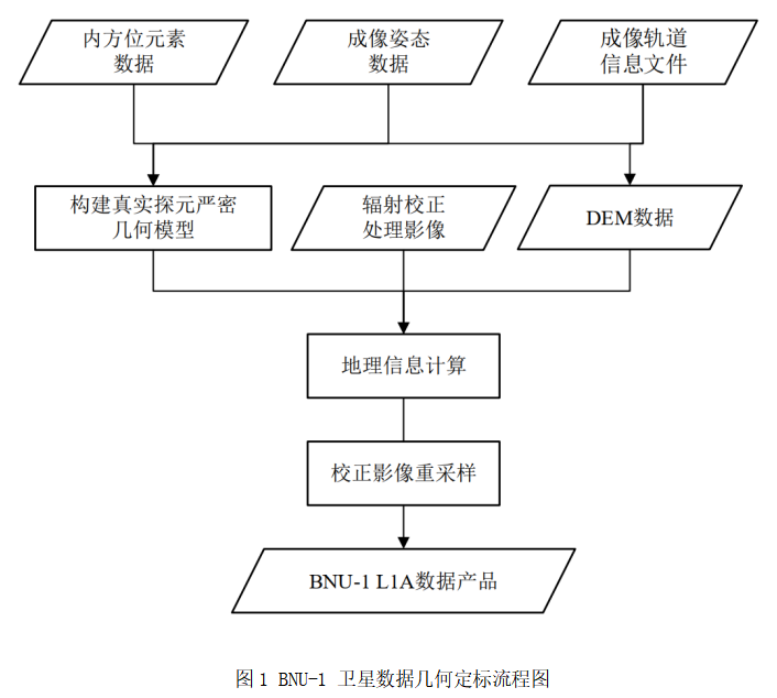\n
第二步是几何校正。几何校正是提高可见光图像几何定位精度的常用方法。通过几何标定模型计算出的地理坐标通常存在约几百米至几千米的几何定位误差。此外,由于极地地区缺乏地面控制点,姿态测量的随机误差无法消除。为了提高BNU-1 L1A产品的几何定位精度,本数据集使用了一种基于同名特征点匹配的自动几何校正方法。该方法包括三个步骤。首先,为待校正的 BNU-1卫星影像选择具有较高几何定位精度的MODIS参考影像。然后,采用尺度不变特征变换(SIFT)特征匹配方法进行BNU-1 L1A影像和对应的参考影像的同名特征点提取。最后,通过匹配同名特征点实现对 BNU-1 L1A 影像的几何校正。\n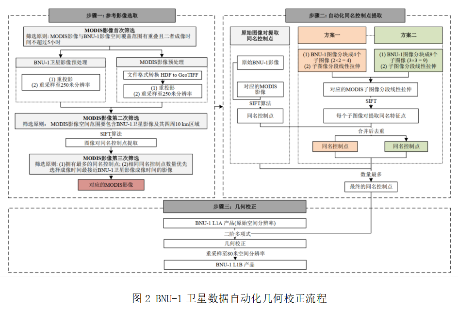", "ds_quality": "
平均几何定位误差 300 m。", "ds_acq_start_time": "2019-09-28 00:00:00", "ds_acq_end_time": "2024-12-31 00:00:00", "ds_acq_place": "南极,北极", "ds_acq_lon_east": null, "ds_acq_lat_south": null, "ds_acq_lon_west": null, "ds_acq_lat_north": null, "ds_acq_alt_low": null, "ds_acq_alt_high": null, "ds_share_type": "apply-access", "ds_total_size": 504420181725, "ds_files_count": 29206, "ds_format": "*.tif *.jpg", "ds_space_res": "80m", "ds_time_res": "5天", "ds_coordinate": "WGS84", "ds_projection": "极方位立体投影", "ds_thumbnail": "ea6159cd-66d5-4ef0-a0bd-32356b6ef4c7.png", "ds_thumb_from": 2, "ds_ref_way": "", "paper_ref_way": "", "ds_ref_instruction": "", "ds_from_station": null, "organization_id": "52b7b79b-860c-49a5-9083-9a70cf8bed5a", "ds_serv_man": "李红星", "ds_serv_phone": "0931-4967592", "ds_serv_mail": "ncdc@lzb.ac.cn", "doi_value": "", "subject_codes": [ "170.15" ], "quality_level": 0, "publish_time": "2026-09-07 09:06:33", "last_updated": "2026-09-07 14:51:38", "protected": false, "protected_to": null, "lang": "zh", "cstr": "11738.11.ncdc.db7784.2026", "i18n": { "en": { "title": "Ice Road Satellite Polar Image Data (BNU-1)(2019-2023)", "ds_format": "*.tif *.jpg", "ds_source": "The data comes from the Iceway Satellite (BNU-1).", "ds_quality": "
The average geometric positioning error is 300 m.", "ds_ref_way": "", "ds_abstract": "
The full name of \"Ice Road Satellite\" is \"Jingshi-1\". It is the first experimental satellite of my country's \"Three-Pole Remote Sensing Constellation Observation System\". On September 12, 2019, it was successfully launched on board the Long March 4B carrier rocket at the Taiyuan Satellite Launch Center. It is mainly used for polar climate and environmental monitoring. It is of great significance for promoting research on polar and global change in my country. The satellite is equipped with an ultra-wide and medium-resolution camera (resolution of 80 meters, width of 800 kilometers), a high-resolution camera and a ship AIS receiver. A single satellite can achieve full coverage observation of the north and south polar regions within 5 days, filling the international 250-meter gap between low resolution and 30-meter high resolution data.\r\n
The BNU-1 data is a Level 1 product that has undergone geometric correction and radiometric correction. The data set contains a total of 2499 images covering the north, south and north poles. The data is stored in a scene-by-scene manner in UTC time system, the data format is *.tif, and the naming method is: BNU1PMSk yyymmddhmmss.yyymmddhmmss. 10k.000k.000k.00kBk \"is a fixed format, and yymmddhmmss represents the image acquisition time, where yy is the year, mm is the month, and dd represents the day. For example,\" 01 \"represents each month starting from the 01st, and hhmmss represents hours, seconds, seconds, and seconds respectively. The BNU-1 satellite image product dataset can be opened and read through remote sensing image processing software, such as ArcGis, QGIS, ENVI, etc. The image covers the polar region of 85°-90° north and south, and includes four multi-spectral bands (B0, B1, B2, and B3): blue, green, red and red edges.", "ds_time_res": "5 days", "ds_acq_place": "Antarctic, Arctic", "ds_space_res": "80m", "ds_projection": "极方位立体投影", "ds_share_type": "apply-access", "ds_process_way": "
Using a geometric positioning method suitable for visible light remote sensing images with few features in polar regions, including two steps of geometric calibration and geometric correction, the key technical problems of the BNU-1 satellite's geometric positioning are solved and the construction of the image processing module of the ground system is improved.\r\n
The first step is geometric calibration. In this step, the precise attitude parameters of the satellite are obtained through a precise attitude determination unit, and based on the geometric calibration data of the satellite laboratory, the obtained inner and outer orientation elements are constructed to build a strict geometric model of each satellite image. After radiation processing, each image in each spectral segment uses the corresponding strict geometric model to calculate the corresponding geographical information, and finally performs re-sampling of the corrected image to obtain an image with geographical coordinates, namely the BNU-1L1A product. The geometric positioning accuracy was evaluated based on 28 images of the Antarctic region and 15 images of the Greenland region. The average geometric positioning accuracy of this product is about 10km.\r\n\r\n
The second step is geometric correction. Geometric correction is a common method to improve the geometric positioning accuracy of visible light images. The geographical coordinates calculated through the geometric calibration model usually have geometric positioning errors of about several hundred meters to several kilometers. In addition, due to the lack of ground control points in polar regions, random errors in attitude measurements cannot be eliminated. In order to improve the geometric positioning accuracy of BNU-1L1A products, this dataset uses an automatic geometric correction method based on matching of feature points with the same name. The method includes three steps. First, select MODIS reference images with high geometric positioning accuracy for the BNU-1 satellite images to be corrected. Then, the Scale-Invariant Feature Transform (SIFT) feature matching method is used to extract the same name feature points from the BNU-1L1A image and the corresponding reference image. Finally, geometric correction of the BNU-1L1A image is achieved by matching the feature points with the same name.\r\n", "ds_ref_instruction": "" } }, "submit_center_id": "ncdc", "data_level": 0, "recommendation_value": 0, "license_type": "https://creativecommons.org/licenses/by/4.0/", "doi_reg_from": "reg_local", "cstr_reg_from": "reg_local", "doi_not_reg_reason": null, "cstr_not_reg_reason": null, "is_paper_in_submitting": false, "belong_to_nieer": false, "allow_update_data": false, "created_from": "fair", "ds_topic_tags": [ "冰路卫星", "京师一号", "南极", "北极", "BNU-1" ], "ds_subject_tags": [ "大气科学" ], "ds_class_tags": [], "ds_locus_tags": [ "南极", "北极" ], "ds_time_tags": [ 2019, 2020, 2021, 2022, 2023, 2024 ], "ds_contributors": [ { "true_name": "陈卓奇", "email": "chenzhq67@mail.sysu.edu.cn", "work_for": "中山大学", "country": "中国" } ], "ds_meta_authors": [ { "true_name": "陈卓奇", "email": "chenzhq67@mail.sysu.edu.cn", "work_for": "中山大学", "country": "中国" } ], "ds_managers": [ { "true_name": "陈卓奇", "email": "chenzhq67@mail.sysu.edu.cn", "work_for": "中山大学", "country": "中国" }, { "true_name": "李新情", "email": "lixq85@mail.sysu.edu.cn", "work_for": "中山大学", "country": "中国" } ], "category": "气象" }