Recently, the team of researchers Youhua from the Northwest Institute of Ecology, Environmental Resources, China Academy of Sciences, in conjunction with the Institute of Qinghai-Tibet Plateau of China Academy of Sciences, China University of Geosciences (Wuhan) and the University of Oulu, Finland, released a high-precision data set of near-surface volume ice content of permafrost in the northern hemisphere with a spatial resolution of 1km. The paper was published in the journal Science Bulletin, and the data was published in the National Glacier, Permafrost and Desert Science Data Center (https://www.ncdc.ac.cn). It is available to users.
Underground ice is the most critical attribute of permafrost to regulate climate, hydrological processes and foundation stability. Due to its deep underground, its fine spatial distribution is basically unknown. Through extensive international and domestic cooperation, scientific researchers systematically compiled measured underground ice data from 1178 locations in the permafrost region of the Northern Hemisphere, and used multi-machine learning ensemble simulation to combine these measured data with paleoclimate, modern climate, remote sensing data, and geology. Combined with other information, a high-resolution (1 km) spatial distribution map at a depth of 5 meters below the upper limit of permafrost in the Northern Hemisphere (Figure 1) was drawn, achieving a breakthrough in grid underground ice mapping. Cross-validation shows that it has high accuracy (R² = 0.86, RMSE = 7%), providing a key data basis for frozen soil impact assessment.
The data set shows that the total underground ice reserves within 5 meters below the upper limit of permafrost in the northern hemisphere are approximately 54,600 cubic kilometers. Among them, the reserve contribution is mainly concentrated in high-latitude permafrost areas: Russia is about 30,202 cubic kilometers, Canada is about 15,985 cubic kilometers, and Alaska is about 3,335 cubic kilometers; the Qinghai-Tibet Plateau in the high-altitude permafrost area is about 2,357 cubic kilometers, and the overall scale is relatively small. From the perspective of spatial pattern, high-ice-containing areas are mostly concentrated in lowland plains, wetlands and swamps at high latitude, such as the southern Hudson Bay and the northern Western Siberian Plain. These areas have low and flat terrain, fine-grained sediments are developed and have good water-containing conditions, which are usually more conducive to the enrichment and long-term preservation of underground ice, and the local ice content can exceed 80%. In contrast, high-altitude plateau and mountainous areas are affected by factors such as slope, runoff erosion and sediment thickness. Hydrothermal conditions are more unstable, and the ice content near the surface is generally low. For example, the Qinghai-Tibet Plateau and the Mongolian Plateau are mostly concentrated in the range of 20% to 40%.
The research was jointly funded by the National Natural Science Foundation of China Youth Project Category A (42525105) and the Gansu Province Science and Technology Plan Project (26RCKA014).
[Paper Information]
Wang, B., Ran, Y., Li, X., Hjort, J., Karjalainen, O., Wu, Q., Sheng Y., Jin H., Zou D., Zhao L., Ma R., Sun Z., & Cheng, G. (2026). Near-surface ground ice map of the Northern Hemisphere. Science Bulletin. DOI: 10.1016/j.scib.2026.02.028.

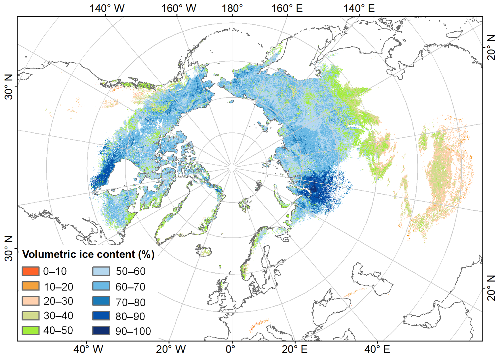
图1 北半球多年冻土上限以下5 m深度体积含冰量空间分布
[Data download address]
Dataset service address: https://doi.org/10.12072/ncdc.nieer.db7052.2025
Dataset service address: https://www.ncdc.ac.cn/portal/metadata/e3cf1a41-8931-4fb5-bec8-297cec6a2284