近期,国家冰川冻土沙漠科学数据中心发布共享了基于地图约束的青藏高原冻土分布变化数据集(1980-2018年)数据集。该数据集由上海师范大学南卓铜教授团队(PermaLab)完成,用户可开放获取。热忱欢迎广大科研工作者下载使用。
青藏高原多年冻土的时空演变对全球变化背景下的区域水文循环、生态系统演替及气候反馈具有深远影响。然而,受限于复杂地形与强烈的空间异质性,如何精准刻画多年冻土的历史动态特征一直是冻土研究的一大挑战。
上海师范大学南卓铜教授团队(PermaLab)发展了空间分辨率为0.1°、时间跨度为39年(1980–2018年)的逐年青藏高原冻土分布长时序数据集。针对早期空间产品难反映退化动态、以及传统模拟受限于“单点校准”偏差等问题,该数据产品创新性地采用了“基于地图的参数校准策略(CaliMAP)”。该策略以高精度的2010年青藏高原多年冻土分布图作为空间约束目标,利用贝叶斯优化算法,对改进的Noah-Tibet陆面过程模型中26个异质性敏感参数进行深度优化。通过提取13组最优参数集进行集合模拟。
验证结果显示,该数据集在热状态模拟上表现高精度,活动层厚度(ALT)、多年冻土顶板温度(TTOP)和10米深地温(GT10m)的均方根误差(RMSE)分别为0.68m、0.41 ℃和1.30 ℃。ALT变化率的RMSE低至0.08 m/10a,充分证明了其捕捉多年代际演变趋势的可靠性。
数据集揭示了1980至2018年间高原冻土的演变特征:
1. 整体趋势:多年冻土面积持续缩减,与季节性冻土的扩张呈显著反向关系。过去近40年间,多年冻土总面积从约126.2万km²减少至108.5万km²,累计损失约17.7万km²,平均退化速率达4.44万km² /10a 。
2. 空间差异:退化最剧烈的区域集中在多年冻土边缘及敏感过渡带,尤以西南部的冈底斯山脉与东部的三江源地区最为显著。
3. 瞬态捕捉:该数据集成功捕捉到了2000至2005年间的特殊波动——受90年代末高原西北部降温事件影响,该时期多年冻土面积出现短暂恢复,一度减缓了区域整体的退化进程。
该高分辨率、长序列冻土数据集在气候变化影响评估、区域水文与生态建模、三江源等关键生态保护政策制定、青藏高原铁路公路等基础设施冻土稳定性评价,以及陆面过程模型与全球气候模式改进等方面具有重要应用价值,可为未来情景预测与适应策略提供关键数据支撑。
该项研究获得了国家重点研发计划项目(2022YFF0711703)和国家自然科学基金项目(42571149, 42171125)的联合资助。
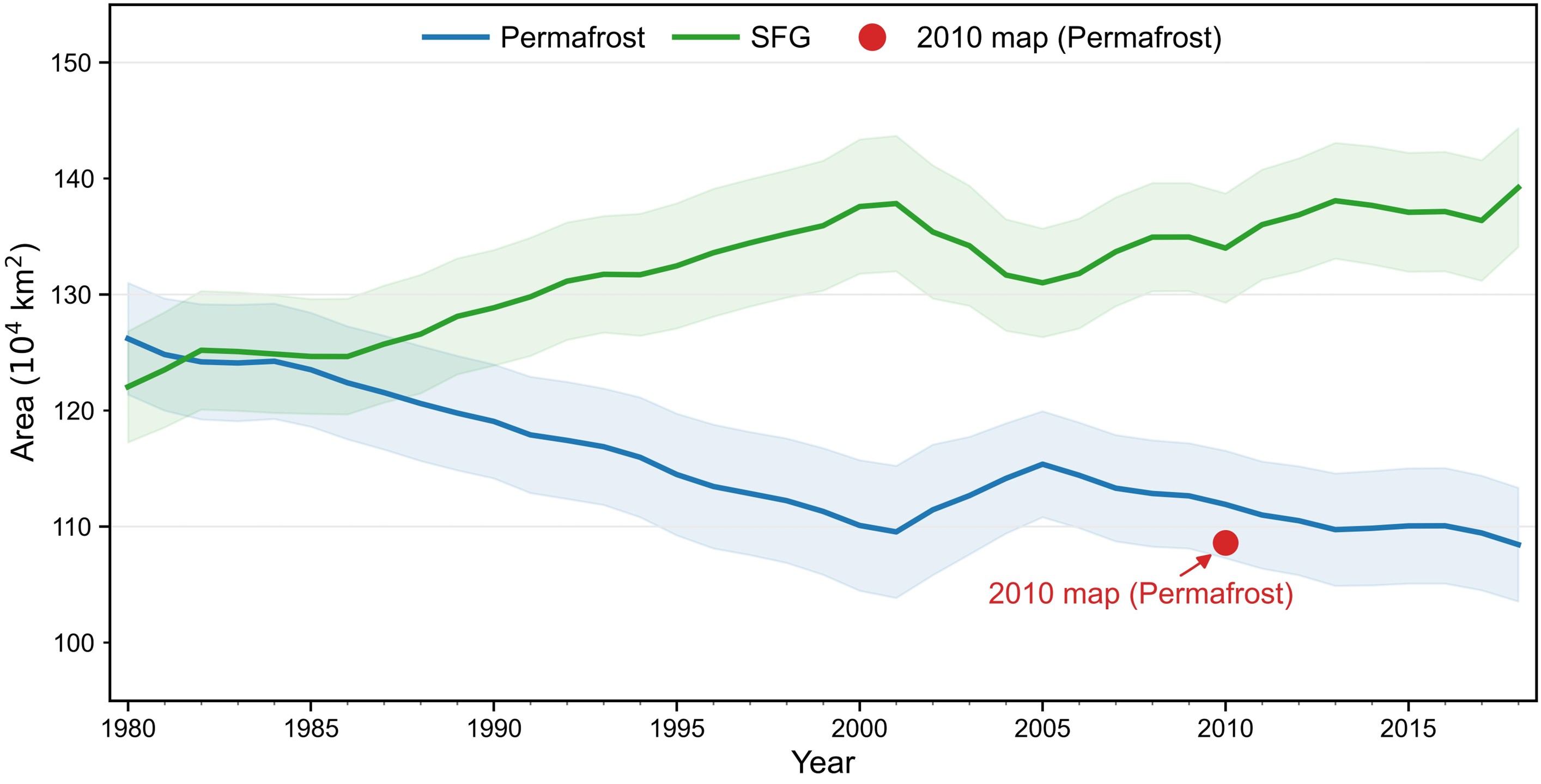
图1 青藏高原多年冻土与季节性冻土(SFG)面积的时间变化(1980-2018年)散点代表模拟的集合平均值,阴影区域表示13个集合成员的95%置信区间。红色圆点表示基于2010年基准图提取的多年冻土参考面积(108.6 × 10⁴ km²)。
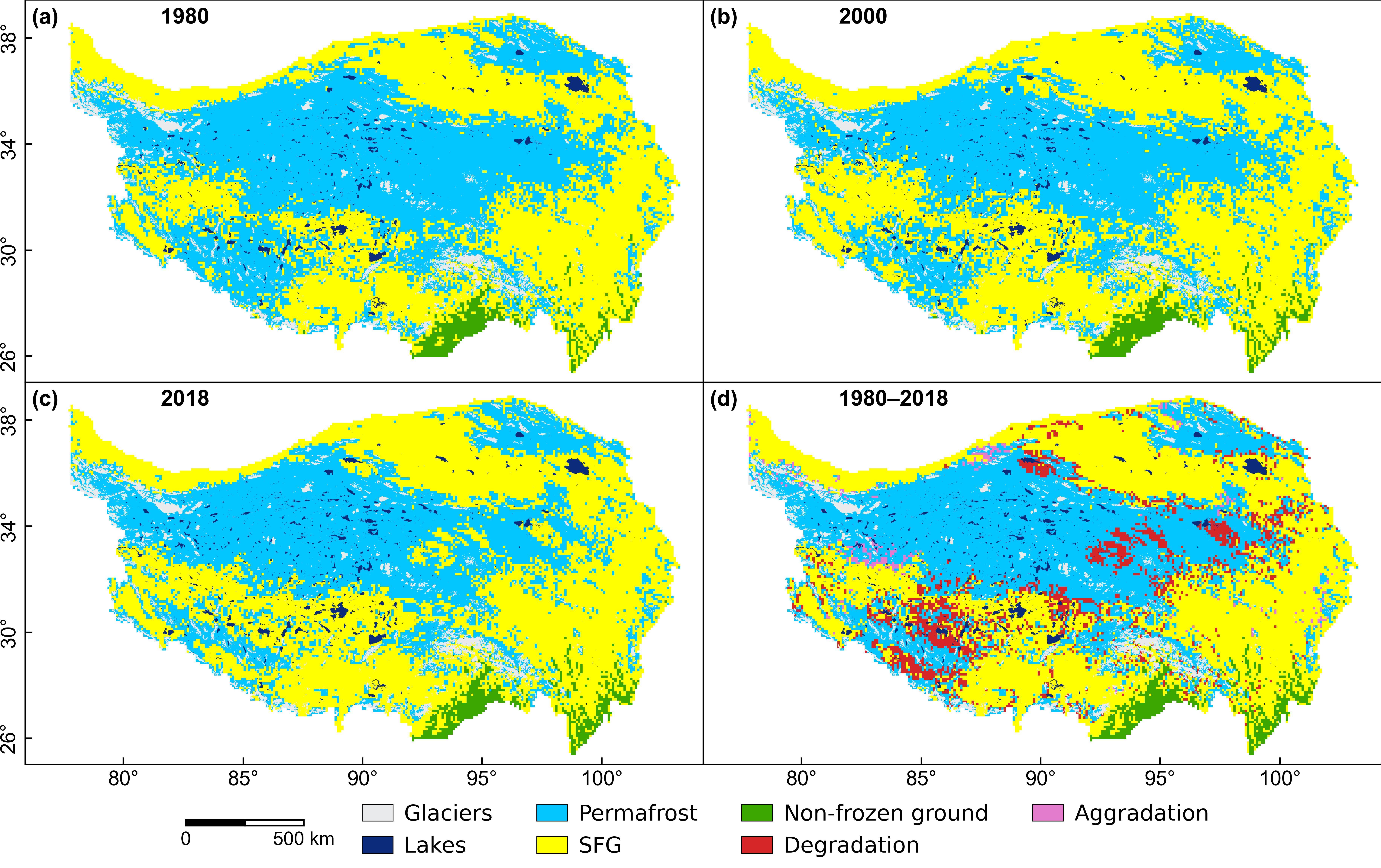
图2 青藏高原冻土分布的时空演化(1980-2018年)(a-c)分别为1980年、2000年和2018年的多年冻土与季节性冻土分布图。(d)1980-2018年间多年冻土范围的空间变化,重点标示了退化区(红色)、新生区(粉色)和稳定多年冻土区(蓝色)。
【论文引用】
1. Hailong Ji, Xiaobo Wu, Shuping Zhao, Zhuotong Nan*. (2026). Constrained simulation of permafrost thermal changes from 1980 to 2018 on the Qinghai-Tibet Plateau. Global and Planetary Change. 263: 105542 https://doi.org/10.1016/j.gloplacha.2026.105542.
2. Shixian Zhang, Shuping Zhao*, Hailong Ji, Pengfei Li,Fujun Niu, Zhuotong Nan*. (2026). A map-constrained dataset of frozen ground distribution changes on the Qinghai-Tibetan Plateau from 1980 to 2018. Data Express in Arid and Cold Regions. (Under review)
【数据集下载地址】
https://doi.org/10.12072/ncdc.permalab.db7196.2026
