0931-4967592
注册
登录
中文
EN
Toggle navigation
首页
综合新闻
数据资源
台站数据
专题数据
期刊数据
模型资源
全球灾害
应急响应
数据汇交
数据汇交文档
汇交数据资源
基地资源
科普
平台介绍
首页
专题数据
默认排序
浏览总数
下载量
更新时间
1/4
长江下游洪涝灾害集成调控与应急除险技术装备专题数据
<p>  本数据专题由国家重点研发计划“重大自然灾害防控与公共安全”重点专项的“长江下游洪涝灾害集成调控与应急除险技术装备(2021YFC3000100)”项目产出。 <p>  本项目由水利部交通运输部国家能源局南京水利科学研究院王银堂原副总工程师牵头负责,联合太湖流域管理局水利发展研究中心、长江勘测规划设计研究有限责任公司、中国安能集团第二工程局有限公司、河海大学等企事业单位及高校共同实施。项目针对长江下游洪涝灾害治理面临着跨地区统筹协调性不足、蓄滞洪区运用难度大、堤防病险隐患多、工程群调度能力不强、灾害风险管控存在盲区等突出问题,本项目提出了跨地区防洪除涝标准协同设计和蓄滞洪区分类管理运用技术;研发了堤防渗漏险情精确定位探测和高性能处置装备;构建了洪涝灾害多元信息分析与智能调度决策支持系统;开发了洪涝灾害全景分析和社会化管控平台并实现业务化应用,开发了洪涝灾害全景分析和社会化管控平台并实现业务化应用,达到了提升防洪治涝技术装备的实用性、先进性,强化洪涝灾害科学分析与风险系统管控能力,形成长江下游防洪安全保障的系统性科技解决方案,强化变化环境下洪涝灾害应对能力和韧性的目的。 <p>  项目产出的科学数据、模型软件、技术方案、行业标准等55个成果经系统整理于国家冰川冻土沙漠科学数据中心正式发布。其中科学数据集36个,包含土地利用、工程信息统计、预报降水、水文气象、潮位预测数据等;模型软件3个,分别为GA-DBN堤防渗漏演化预测模型、SVM堤防渗漏演化预测模型和洪涝灾害多元信息分析与智能调度决策支持平台;技术方案14个,包含洪涝灾害应对韧性评价方法、防洪除涝工程一体化智能调度技术方案、洪涝灾害多源异构信息获取与知识发现技术等;标准规范2个,为跨地区防洪除涝标准协同设计技术指南和蓄滞洪区分类管理运用技术指南。
创建时间:
2025/04/18
数据集总数:
52
浏览总数:
109025
下载总数:
132
文件大小:
32.2 GiB
冰冻圈长时序关键要素数据专题
本专题由中国科学院西北生态环境资源研究院牵头、联合中科院青藏高原研究所、兰州大学、中科院空天信息研究院、云南大学,生产冰冻圈关键要素冰川、冰湖、冻土、积雪、沙漠等要素的长时序数据。
创建时间:
2024/12/05
数据集总数:
23
浏览总数:
137926
下载总数:
1867
文件大小:
14.9 TiB
风电场、光伏电站生态气候效应和环境影响评价研究数据专题
<p>  近日由国家重点研发计划“可再生能源与氢能技术”重点专项“风电场、光伏电站生态气候效应和环境影响评价研究(2018YFB1502800)”项目产出的数据成果正式在国家冰川冻土沙漠科学数据中心(www.ncdc.ac.cn) 发布并提供下载,热忱欢迎广大科研工作者关注并获取数据。 <p>  本项目由中国科学院西北生态环境资源研究院高晓清研究员牵头负责,并联合国家气候中心、中国环境科学研究院、北京华新天力能源气象科技中心、清华大学等多家科研院所、高校、企业共同实施。项目以“可再生能源可持续发展”“生态文明”为导向,开展“风电场局地生态气候效应事实与机理”“光伏电站生态气候效应事实与机理”“大规模风能太阳能开发的气候效应情景预估”“风电、光伏行业典型产品生命周期评价方法”“气候环境约束下我国风电和光伏产业健康发展对策”等研究,以期为国家应对气候变化战略、可再生能源战略和行业清洁生产提供有效科学支撑。 <p>  在全球大规模开发风能和太阳能资源的背景下,为了全面认识风电场和光伏电站的生态气候效应,本项目旨在通过多种手段的综合观测和研究,揭示这些新能源设施对气候、生态系统及环境的影响机理。项目利用地面定位观测、地基遥感、无人机和卫星遥感等多种探测手段,针对海上和陆上风电场,开展综合观测和调查,分析风电场对气候要素、近地面能量水分循环、土壤性质、植物群落、海洋生态环境、海洋生态系统结构和功能以及生物多样性的影响,发展完善了风电场参数化方案,揭示了不同应用场景风电场局地气候效应机理。同时,通过光伏电站内外对比观测,厘了清湖陆光伏电站对局地气候影响的事实,确定了其陆面过程特征,发展了光伏电站参数化方案,揭示了局地气候效应机理。此外,采用全球气候模式模拟结果和动力降尺度相结合的方法,揭示了未来气候变化情景下我国风能、太阳能资源的可能变化,形成了高分辨率气候情景,阐明了未来风电场和光伏电站布局的气候影响及其不确定性。基于终点破坏模型,构建了适用于我国风电、光伏行业的生命周期环境影响评价模型方法,开展生命周期评价,判识了行业环境影响、碳排放关键环节,为低碳发展、节能降耗及环境影响评估提供技术参数及意见建议。项目基于风电光伏发电潜力评估技术,考虑消纳时空适配性,提出了互补发展的消纳措施与规划策略提出了基于气候影响约束下的发展布局建议,综合考虑发展布局、气候效应、产品生命周期环境影响,研究了相应政策措施与规范化、健康发展激励策略。该项目通过多手段综合观测和研究,旨在揭示风电场和光伏电站对气候、生态系统及环境的影响机理,为风能和太阳能资源的有序开发利用提供科技支撑。相关研究成果将为优化选址及生态环境保护、生态修复等工作提供科学依据,为可再生能源与生态环境协调发展提供了重要科学基础和技术支撑。
创建时间:
2024/12/03
数据集总数:
14
浏览总数:
34985
下载总数:
238
文件大小:
22.9 GiB
天水水土保持科学试验站数据专题
黄委会天水水土保持科学试验站2023年观测数据成果在国家冰川冻土沙漠科学数据中心(www.ncdc.ac.cn)发布并提供下载,其他数据后期将逐步发布,热忱欢迎广大科研工作者关注并获取数据。 黄河水土保持天水治理监督局(黄河水利委员会天水水土保持科学试验站)创建于1942年,是国内建立最早的水土保持科研机构,主要从事水土保持科学试验、示范、推广等工作。2000年4月,在继续保留水土保持科学试验职能的同时,成立了黄河水土保持天水治理监督局;2003年,成立了黄河上中游管理局直属天水水政监察(水土保持监督)支队和黄河流域水土保持生态环境监测天水分中心,主要负责黄河上中游甘肃、青海境内及新疆维吾尔自治区内陆河地区的水土保持综合治理、监督、管理、协调、监测等工作,以及承担黄河干流河源至下河沿河段和跨省(区)重要支流湟水河(含大通河)、渭河(甘肃省境内)干流长达3729km河道建设项目监督管理和取水许可管理工作,为黄河上中游管理局的直属事业单位。设有罗玉沟、龙王沟和梁家坪3个试验设施完善的水土保持试验场,罗玉沟、吕二沟、桥子东沟、桥子西沟4个水土流失观测站和1处机关办公场地。
创建时间:
2024/11/14
数据集总数:
47
浏览总数:
139264
下载总数:
572
文件大小:
8.8 GiB
黄河水利委员会西峰水土保持科学试验站水土保持观测数据专题
黄河水利委员会西峰水土保持科学试验站在国家冰川冻土沙漠科学数据中心(www.ncdc.ac.cn) 正式发布了黄土高塬沟壑区典型流域水土保持科学观测数据集,并提供下载,热忱欢迎广大科研工作者关注并获取数据。 黄河水利委员会西峰水土保持科学试验站,成立于1951年10月,是黄河水利委员会设在黄土高塬沟壑区的水土保持科学试验单位。为集科学研究、监督监测、治理示范、管理服务于一体的综合性事业单位,先后开展了黄土高塬沟壑区水土流失规律试验观测、水土保持单项治理技术研究、中小流域综合治理模式、水保措施减水减沙效益分析、水土保持优良植物引进繁育推广、径流高效利用及节水灌溉技术、水土保持遥感技术应用等科研工作,为黄土高原水土流失治理与生态文明建设提供了有力的技术支撑。
创建时间:
2024/10/29
数据集总数:
83
浏览总数:
323838
下载总数:
1616
文件大小:
793.3 MiB
涉水重大基础设施安全保障技术研究与工程示范数据专题
本项目由中国科学院西北生态环境资源研究院赖远明院士牵头负责,该项目针对涉水重大基础设施安全保障技术的关键问题,以跨江(湖)越海隧道、桥梁和高寒地区大型水库等为对象,开展基础理论研究和技术研发,构建综合防灾减灾、智能管控和应急救援技术体系,完成深中通道等工程示范应用,制修订安全保障技术标准规范,提升我国涉水重大基础设施安全保障水平。 针对跨江(湖)越海隧道、桥梁和高寒地区大型水库、桥梁及地下洞群等涉水重大基础设施,研究结构全寿命周期服役性能演化机理、模型及可靠度评价方法、诱发典型病害的危险源辨识、灾变演化机理;研究不良地质条件下海底沉管隧道病害诱发机理、破坏模式及主动防控技术;研究饱和交通量下海底钢壳混凝土沉管隧道和互通立交式海底隧道防火、通风排烟、应急救援技术及智能仿真控制系统和安全综合控制技术;研究海上超大跨悬索桥风、浪、流耦合灾害作用、危险性评价及灾变控制技术;研究西北高寒和冻融极端气候条件下大型水库、桥梁及地下洞群典型涉水基础设施系统冰冻害破坏模式、破坏机理及冰冻害主、被动防治技术;研发基于大数据的涉水重大基础设施实时健康监测、安全智能诊断管控系统、灾害预警技术及防控和超前加固技术。
创建时间:
2024/10/22
数据集总数:
72
浏览总数:
125585
下载总数:
135
文件大小:
244.8 MiB
绥德水土保持科学试验站专题数据
近日黄河水土保持绥德治理监督局(绥德水土保持科学试验站)2023年最新观测数据成果正式在国家冰川冻土沙漠科学数据中心(www.ncdc.ac.cn)发布并提供下载,其他数据后期将逐步发布,热忱欢迎广大科研工作者关注并获取数据。 黄河水土保持绥德治理监督局(黄河水利委员会绥德水土保持科学试验站)隶属于黄河水利委员会黄河上中游管理局,属国家事业单位。黄河水利委员会绥德水土保持科学试验站成立于1952年,前身是陕北水土保持工作推广站,1956年归属黄委领导,是以水土流失规律观测、水土保持科研、示范推广为主要任务的公益性事业单位。主要任务是研究黄丘一副区水土流失规律、探索小流域水土保持措施的科学配置、不同治理措施的减水减沙效益以及对黄河水沙变化的影响。同时,总结水土保持治理经验和措施,推广先进治理经验,进而探索适合当地的水土流失控制与治理途径。
创建时间:
2024/09/25
数据集总数:
118
浏览总数:
747501
下载总数:
2072
文件大小:
451.5 MiB
黄河流域水域生态数据专题
  为积极响应国家生态文明建设号召,进一步改善水域生态环境、维系河湖生态功能,增强青年学生爱护江河湖库意识,建设人与自然和谐共生的美丽中国。由河南师范大学水产学院提供的黄河流域水域生态数据正式在国家冰川冻土沙漠科学数据中心(www.ncdc.ac.cn) 发布。
创建时间:
2024/09/03
数据集总数:
6
浏览总数:
16387
下载总数:
45
文件大小:
4.7 MiB
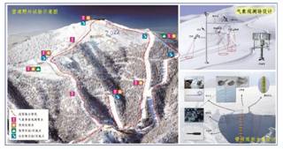
赛事用雪保障关键技术研究与应用示范数据专题
本项目由中国科学院西北生态环境资源研究院王飞腾研究员牵头负责,项目由中国科学院西北生态环境资源研究院、北京师范大学、中国气象科学研究院、哈尔滨体育学院、河北省气候中心、山东师范大学、黑龙江省亚布力体育训练基地、张家口卡宾滑雪装备制造有限公司、慧科教育科技集团有限公司、密苑(张家口)旅游胜地有限公司等多家单位共同承担,形成产学研结合的一体化创新团队。雪上项目是冬奥会的“重头戏”,占金牌总数的70%。赛事用雪保障技术是确保北京冬奥会雪上项目赛事成功举办的重要基础和前提,其关键技术体现在造雪、储雪、铺雪、雪质监测预报及相关补救措施等一系列雪务工作上。该项目拟通过组建以科研院所、冰雪高校、滑雪场和企业为主体的联合团队,针对滑雪场造雪、储雪、雪质保障和赛道维护等,研发适合中国冰雪产业发展的一体化解决方案,一方面为本次冬奥会雪上项目提供技术保障,另一方面旨在推动我国的雪务工作与国际全面接轨,并服务于后奥运时代我国冰雪产业“南展西扩东进”的战略目标。本项目此次共发布12个数据集,包含造雪系统实验数据、我国三大滑雪场气象数据、滑雪跳台雪堆数据、张家口赛区气象观测数据等。该项目以北京冬奥会的滑雪场及其它多个滑雪场为研究对象,通过观测、试验和数值模拟等方式,开展赛道雪质的判定、监测和预报,冰状雪赛道制作,多种手段储雪,以及高效能造雪模式及造雪成套化等关键技术的研发工作。
创建时间:
2023/07/20
数据集总数:
12
浏览总数:
28510
下载总数:
12
文件大小:
406.4 GiB
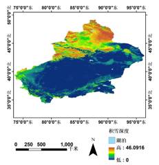
国家冰川冻土沙漠科学数据中心2020年度开放基金项目数据专题
国家冰川冻土沙漠科学数据中心2020年围绕冰川冻土沙漠积雪专题数据制备、数据生产及技术、数据融合与集成方法研究等内容,支持开放基金10项,产出的成果数据主要包括新疆地区积雪深度、喀喇昆仑山流域冰川表面高程变化及表面运动速度、青藏高原冰川中流线、阿尔泰山流域冰川消融期反照率空间分布等内容。
创建时间:
2023/06/21
数据集总数:
11
浏览总数:
48305
下载总数:
250
文件大小:
270.6 GiB